6 miles. Start/finish: Tardebigge New Wharf, Alester Rd, Tardebigge B60 1NF. Terrain is good on footpaths, tracks and through fields. Stretches on minor roads. Footpaths are generally well marked but can be very muddy.
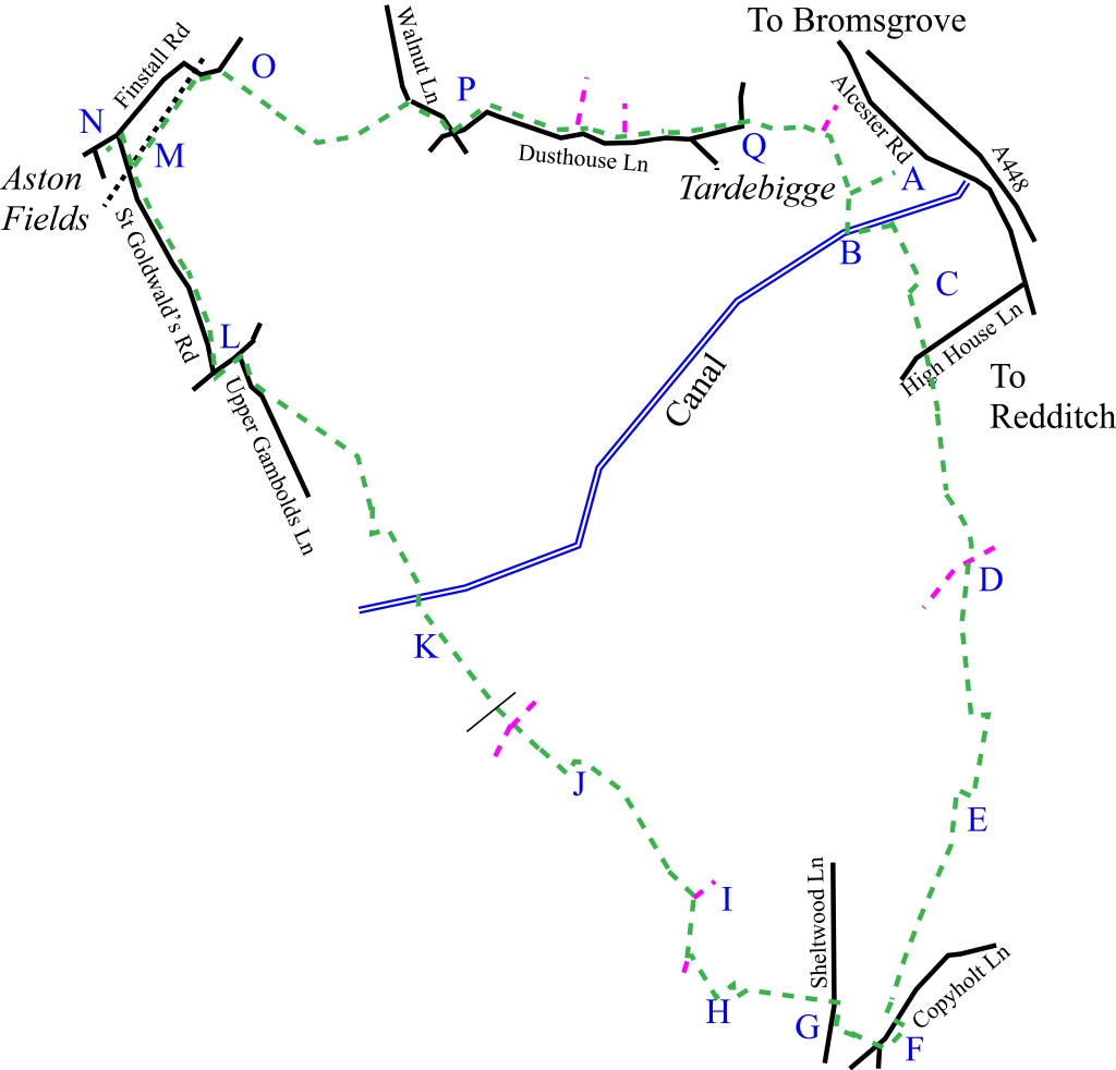
Follow the track round the rear of the boatyard (A) and cross the canal at the top lock (B). This is lock 58 on the Worcester and Birmingham Canal. To your left is Tardebigge tunnel and Birmingham. Follow the path which lies to the side of the house and heads towards the 18th Century St Bartholomew’s Church (C). The path zigzags around the church and school (affording excellent views to the North and West) until it comes out on a road.
The path continues on the other side of the road and then straight across three fields. At the start of the fourth field after crossing a stile, the path splits (D) but our route is more clearly defined and runs slightly to the left with the wind turbine to your right. Keep straight on across another two fields until you come to a yard. Head straight on, the path now follows the hedgerow left, then right (hedge on your left) and heads towards Brotherton’s Wood (E). The path follows the perimeter of the wood (across the first of many small wooden bridges that will be crossed on this walk) and around Banks’s Green Farm eventually coming out at a small road (F). Turn right along the road and look out for the path on your right just before the house.
Follow this path until it meets another road where you will turn right (G) and then left into another path. This path runs alongside a field and left into an overgrown corner of the field (H). Head through the overgrowth and then follow the path down to the right until a wooden bridge is met. Cross the bridge out of the thicket and follow the path up the field to the stile on the left. Across the stile with the farm on your right (I) and a short distance along you come to a gate. Ignore the path to the right and turn left before the gate so the farm is behind you and the hedge is on your right. Keep straight on – the path crosses a gate and then leaves the field via a gate and bridge (J). Follow the path to the left and then to the right.
Gently heading uphill and then downhill, the path crosses another path, bridle path and service road eventually a stream (K) via a wooden bridge. The path continues gently uphill until the canal is met again. This flight of thirty, narrow locks is the longest in Britain as they take the canal to Worcester. The path crosses the accommodation bridge over the canal and heads in virtually a straight line along the side of fields, past a pond until a track and eventually, a road is met (L). Follow the road to the right, turn left then right at the junctions and head into Aston Fields.
The next path runs alongside the railway line (M) but refreshment is available at the Ladybird Inn (N) just ahead. Retrace your steps over the bridge and follow the footpath as it follows the course of the Lickey Incline. At one time locomotives were stationed on this section of the railway to assist trains in climbing the two-mile incline. Turn right at the road and then take the footpath on your right (O) that runs alongside Bromsgrove Rugby Football Club. The path follows a clear well-marked course (this is the Monarch’s Way) to a small road. Turn right at the road and then left at the crossroads (P).
The small road takes you past attractive and interesting buildings. Just past Dusthouse Farm the road curves to the left but take the footpath straight on (Q). Another small wooden bridge is crossed as the path curves to the right heading towards the church and the bridge over the canal. Cross the canal, walk back up the towpath to the top lock (B) and you are now at the end of the walk.