6.5 miles. Start: Alvechurch Railway Station, B48 7NR, Finish Bromsgrove Railway Station, B60 3SF. This walk is well-marked and easy to follow. It is along a canal towpath, footpaths, minor roads and pavements. There are good refreshment opportunities especially if the walk is begun at midday on a Saturday. Details of all the pubs mentioned below can be found at WhatPub.com. If you are planning to do the walk on a day other than a Saturday, it is definitely worth checking the pub opening times on their website or Facebook page.
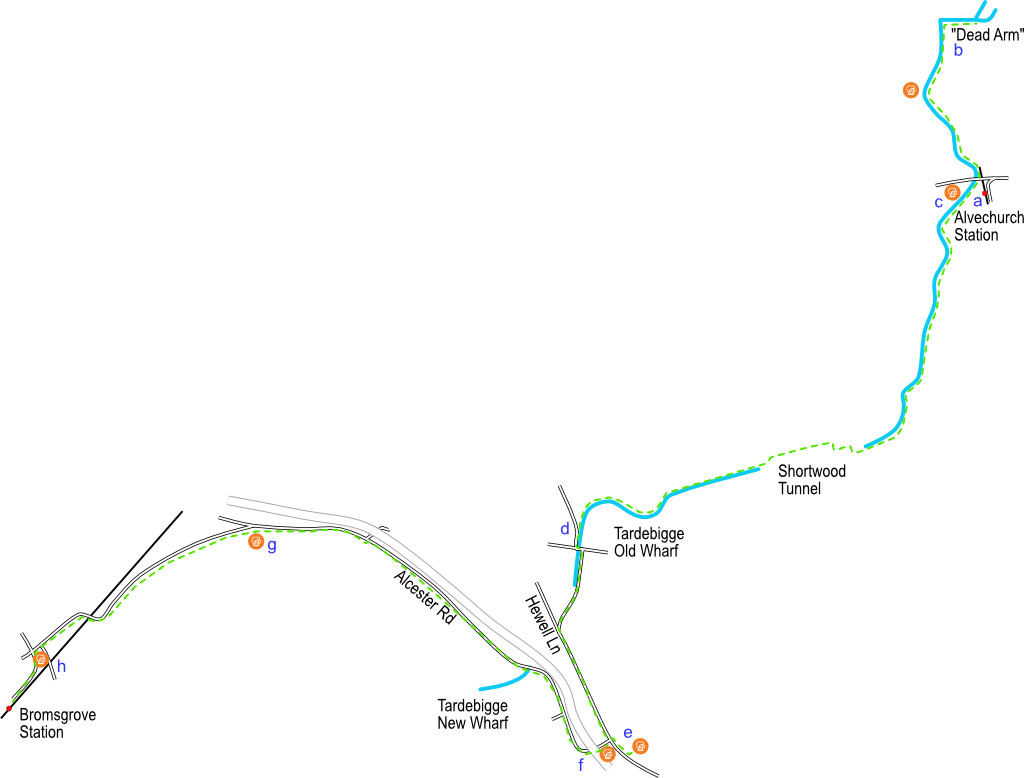
This A.B.C walk can be broken into stages or completed in one go and is ideally done on a Saturday, starting at 12pm at Alvechurch railway station (a). Pubs serve cask beers and snacks including cobs.
If you arrive before midday, a walk down the Worcester and Birmingham canal towards the “dead arm” is recommended. The “dead arm” is a short section of the canal that was created when the canal was rerouted to make way for the construction of the M42 motorway. It contains interesting water plants and wildlife. Turn left as you leave the station car park, cross over the railway bridge and then walk down the slope to the canal. Turn right (towards Birmingham) under the canal bridge and walk along the towpath for ¾ mile. You will pass close to the Crown and then see the large concrete bridge carrying the M42 over the canal. The “dead arm” (b) is straight ahead. Turn around and retrace your steps back along the towpath and onto the road by the station. Turn left.
The Weighbridge (c) is adjacent to the canal on the Alvechurch Boat Centre base at Scarfield Wharf. If you would like to find out more about this waterway, it is worth visiting the website of the Worcester Birmingham & Droitwich Canals Society (wbdcs.org.uk) who have monthly meetings at the Weighbridge.
When you leave the pub return to the canal but turn left (towards Worcester) along the towpath. You will see moored residential and hire boats on your right. The 3½ mile walk to our next pub will take about an hour and a half. This section of the canal is good for spotting kingfishers, moorhens, coots, buzzards and other wildlife and look out for the “boob” tree just after you pass the moored boats.
The trees get closer and it gets darker as you approach the northern portal of Shortwood tunnel. Two boats can pass each other in the tunnel and you can see straight through it. The path leaves the waterway but is easy to follow as it twists and turns with trees on either side of you. Before it descends back down, it crosses an open field. Look out for Tardebigge Church spire, slightly to the left on the skyline. The lumps of rough ground you can see near at the top of the path are the spoil from when the tunnel was dug out by navvies in 1797. You will re-join the canal towpath at the southern portal of the towpath. The path is easy to follow but is narrower than the section you have just walked. Even so, cyclists do (carefully) ride along the whole 30 mile length of the canal. This is a very pretty section of waterway but you will be leaving it at Tardebigge Old Wharf (d). The towpath exits onto a country lane (turn left) but you can get an ice cream at the boatyard which is owned by Anglo Welsh boats. Just past the boatyard there is a T-junction. Turn left and cross the canal then immediately turn right. Take care as you walk up the road. To your right you can see below and say goodbye to the canal for now before it enters Tardebigge Tunnel. The road meets the B4094 (Hewell Lane), not a busy road but certainly nowhere near as quiet as the ones you’ve walked along so far. Carefully cross the road and turn left. Walk along the tarmac pavement until it comes to an end close to the impressive (but now disused) stone entrance to Hewell Grange. Cross the road carefully and continue to follow the path. You will pass the entrance to HMP Hewell and on your right Alcester Road. The Tardebigge is a large roadhouse.
Turn left into Tardebigge Court (e) and through the archway to Alestones micropub. If food isn’t available you can order something to eat from the café opposite. Retrace your steps to Alcester Road. Our next stop is 1.8 miles away. Carefully cross the road and turn right walking past the Tardebigge, then turn left into Alcester Road (B4184). After passing under the A448 (f), the pavement turns right and descends towards Bromsgrove. You will pass the tall thin spire of St Bartholomew’s Church and the southern portal of Tardebigge Tunnel (it is underneath you) where you will see, and finally say goodbye, to the Worcester and Birmingham canal. The UK’s longest flight of locks starts here at Tardebigge New Wharf. Follow Alcester Road as it descends. The footpath crosses the road by the bus stop and then back again just before you come into the village of Finstall and the Cross (g).
When it is time to leave, turn left out of the Cross and walk down Finstall Road (B4184). Our next stop is one mile away. The footpath takes you close to Bromsgrove Rugby Club. The route to Aston Fields takes you over the railway and eventually to the Ladybird (h) where you can celebrate the end of this walk. Bromsgrove railway station is a few minutes walk from here. You started your journey at (A)lvechurch railway station and finished at (B)romsgove and walked along the (C)anal.