5 miles. An easy to follow circular walk with easy terrain and well-marked paths. Some sections on roads or along pavements and some larger roads have to be crossed. The final section follows a canal towpath. Start point is Alvechurch Railway Station, Alvechurch B48 7NR.
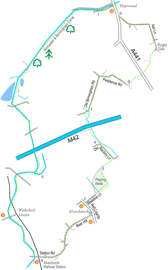
From Alvechurch Railway Station car park (a), follow Station Road (pavement on the left side of the road) down as it continues to Bear Hill. Turn left (b) at the fish and chip shop on Red Lion Street and continue until you come to the Red Lion pub. Carefully cross the road (c) and walk into Meadow Lane. This pleasant lane comes to an end at a little bridge over a stream. Our route follows the stone path anti-clockwise around the playing field before turning left beside the trees, or you can also veer left at the bridge and go clockwise around the playing field. Either way, you will end up in the corner of the field (d) and a gate which you will go through. Follow the path until it meets Rectory Lane where you will turn left. The garden of the house on your right makes a prominent feature of the watercourse that passes through it.
The lane will turn to the left but continue to follow the path straight on over the stile (e) and follow the line of the stream. The path crosses another stile and veers very slightly to the right across a small field before passing under the M42 motorway. It then meets Old Birmingham Road, where you will turn right (f). Follow the road to Pestilence Lane where you will turn right. Ignore the path on the left and follow the lane as it weaves beside a few houses before continuing a short distance until it finishes by a metal gate and some trees (g). Leave the tarmac lane by turning left and follow the tree lined path.
The path meets the A441 that leads to Hopwood Services. This is a busy road, so cross it carefully. Follow the path opposite until it meets the small lane beside the rugby club. Follow Ash Lane as it veers left eventually meeting the A441 by the petrol station (h). Turn right and follow the pavement until you are opposite the Hopwood House pub. This is another busy road which you will need to cross carefully.
Follow the little lane beside the pub and join the towpath (i) of the Worcester & Birmingham Canal. Follow the towpath as it heads away from Birmingham and towards Worcester. You will pass beside ponds on your left (j) and Lower Bittell Reservoir to your right. It was built along with Upper Bittell Reservoir in the 18th Century to feed the canal.
Continuing south along the towpath, shortly after passing under the M42, you will turn left and then right across a quiet stretch of waterway (k) known as the Crown Meadow or ‘Dead’ Arm. This is the former line of the canal that used to be the line of navigation before the motorway and new line of canal was built in 1985.
The towpath passes under the railway and continues past the hamlet of Withybed Green and the Crown pub. Our walk finishes at Alvechurch Marina which is a good place to enjoy a beer at the Weighbridge pub.