7.5 miles. Start/finish: Near J1 of the M42 either in the car park of the Forest pub, Lickey End, B61 0EZ, or Long Meadow Road (b). Well marked footpaths, sections on pavements and on minor roads.
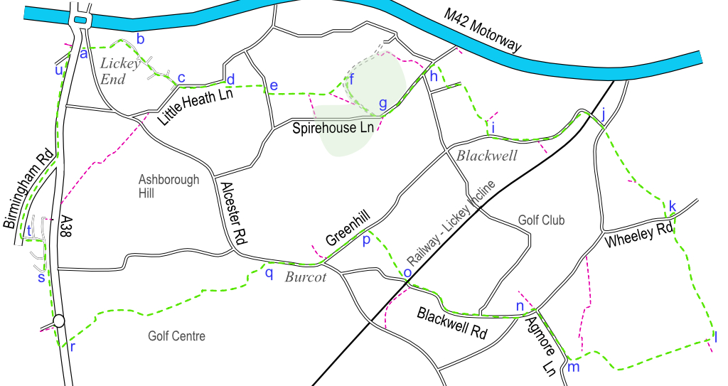
Leave the car park (pub users only) of the Forest pub (a), into Alcester Road. Cross over, turn right and then take the path on the left that takes you into the modern housing estate and onto Long Meadow Road (b) which you will now follow. Continue as the pavement descends, turn left onto Meadowvale Road and at Little Heath Lane cross the road and turn left (c). You will have now left the modern housing estate but the pavement continues past a few houses before it ends. After a very short distance, it is safer to cross the rural road, passing the entrance to Bromsgrove Garden Centre, before crossing back again and taking the path to the right (d), up a gravel drive to the left of a house.
The path crosses a stile where horses are trained and up a short track to a small road (e). Turn right onto the road and then after a short distance take the gate on the left into the field. Follow the path as it gently climbs, ignoring the path on the right before veering slightly left to cross the field diagonally. Ahead you will see trees which line the track where you will turn right (f). Follow the track as it descends onto Spirehouse Lane where you will turn left (g). Carefully cross and walk up the steep lane. You will pass Hunters Hill College on your left and St Catherine’s Road on your right, continue straight until you reach a well-marked footpath (h) on the right called Elephant Way which you will take. The footpath descends and meets a small service road where you will turn left. Just before the cul-de-sac ends, turn right into the next path and follow it (ignore the path on the left) until it meets Linthurst Newtown and the village of Blackwell. Turn left (i) following the pavement and over a bridge that crosses the railway line.
This length of track is the steepest continuous mainline railway incline in Great Britain and is known as the Lickey Incline. Steam and diesel locomotives known as Bankers would help pull carriages up the two miles of track that leads to Birmingham.
Shortly after the bridge over the electrified track you will meet Blackwell Road (j). Cross the road and pick up the footpath directly ahead of you. It climbs steadily and then descends across fields and a track, eventually coming out on Wheeley Road where you will turn left. As you approach the two cottages on your left, look for the track opposite on the right (k) which you will take.
The track follows a straight course and offers superb views towards the Malvern Hills. Eventually, the path meets farm buildings and a concrete path. It turns right through the farm. (Further down the concrete track to the left is the attractive 17th Century Cattespool Farmhouse.) However, our path (l) is straight ahead. Follow this bridle path along its straight course and then beside hedgerows before turning right and left. Ignore the footpath to the right and head across the field towards the buildings where you will come out on Agmore Lane (m). Turn right and follow the road until the T-junction where you will turn left onto Blackwell Road (n). There is no pavement along Blackwell Road and although it is not busy, do listen out for traffic as it is very narrow in places. Ignore Hollow Tree Lane on your left and then Agmore Road on your right. Continue walking carefully down the narrow road, under the railway bridge and immediately pick up the footpath to the right (o). You may see goats and sheep in this field. Follow the path to Greenhill where you will turn left (p). Follow the pavement beside the road until you meet Alcester Road at Burcot. Turn right at the roundabout and look out for the track (the footpath is marked) on your left (q) after the houses, which you will take.
Look out for and take the footpath to the right. The route continues beside and sometimes on a golf course before following a track downhill then veering left and meeting a layby on the A38 (r). The road is busy so be very careful when crossing it. Once you have crossed the Bromsgrove Bypass, walk a few metres to the layby to pick up the footpath. Although it runs parallel to the A38, the path is thankfully shielded by an earth bank and trees for most of the way. Turn right here and follow the path north. Carefully cross Slideslow Drive and pick up the path again heading in the same direction with buildings on your left and a water course on your right. After 300m you will come to a path on the left that leads to Burcot Lane. Ignore this, but take the next path on the left beside modern houses that takes you to Roman Way (s) where you will turn right. Ignore the first road on your left, but take the second, Townsend Avenue. This leads to Birmingham Road where you will turn right (t). Follow Birmingham Road north and follow the pavement round to the left onto the A38. The path runs uphill and finishes near the Ambulance Station service road (u) where there is a pelican crossing to take you back to the Forest pub.