6.5 miles. Broome can be found off the A450 south of Hagley. With St Peter Church, Broome DY9 0HB on your left take the road ahead instead of to the left. There is space for two or three cars on the left. Alternatively, start at point F. Good terrain, through fields. Short distances on minor roads. Most footpaths followed are clearly marked or signposted.
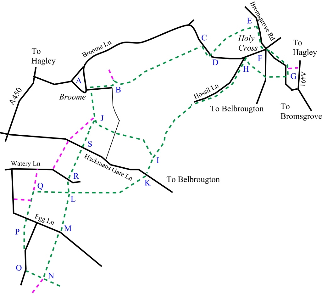
Follow the small road away from the church (A) (built in 1780) and turn left at the T-junction (B). The road turns into a track and curves around the back of a house. Follow the track straight on (ignoring the path to the left) as it opens out onto the left-hand side of a field. Follow the path for three-quarters of a mile through the open gates (or over the stiles if they are closed) until you reach the road (C). Turn right and follow the road for a short distance until you meet the path on the opposite side (D). Take this path as it climbs and meets a plantation where there used to be a sign warning of adders. The path runs to the left of the plantation eventually going over a stile into a field. Follow the path as it gently curves to the right and go over the stile. Walk down by the side of the houses until you meet Bromsgrove Rd (E). Turn right and walk along the side of the road (there is a footpath) and admire the red sandstone through which the road is cut. You are now entering Holy Cross with the Bell and Cross (F). This is a historic pub listed in CAMRA’s National Inventory of Unspoilt Interiors. When you leave the Bell and Cross by the front entrance, turn right and cross over but do not take Belbrougton Rd. Walk along Bromsgrove Rd towards the A491. Walk on the right-hand side of the road for less than half a mile until you meet the path to the right (G). This path meets Belbroughton Rd (by the pub car park). Go straight across the road and take the path adjacent to the club and go through the allotments. Eventually, the path goes past a pretty pond and meets a small road named Hossil Lane. Take this road and follow it past the football pitch (H). Eventually, the road turns into a track and then a path. You will follow its straight course (past a house with solar panels and wind generators) for a mile.
Shorter route: You can now take a shorter route by taking the path to the right (I) over a stile and cutting across a ploughed field. At the opposite side of the field, you will cross a small road/track. Go straight across and walk across another field. The path then splits in two. Take the right-hand path (J) and head down towards the stile and hedgerow.
If you are not taking the shorter route cross Hackmans Gate Ln (K). The path heads across the field almost straight on, slightly to the right but not towards the gap in the corner of the field. Cross the footbridge across the stream. At the next field ascend slightly to the right across the middle of the field. When you are a little higher look for the path marker and stile which you will cross. The path is much clearer now and runs to the left of a fence. At the intersection of paths (L) turn left and follow the path with the hedgerow on your left until it meets the small Egg Ln (M). Turn right along the road and then very shortly left back onto the path. Follow the path in a straight line with hedgerows on your right until the path intersection (N) where there is a hedge and wooden pole carrying electricity. Turn right and head up the slope (hedge on your left) until you reach the lane (O) opposite Sion House. Turn right and follow the lane until you reach the footpath (P) on the left which takes you diagonally across a field (P) and then straight across Egg Ln. Follow the path with the hedgerow to your left and admire the wonderful views until you get to Yieldingree Farm and a service road where you will turn right (Q).
An alternative route at (Q) takes you straight on, down a service road to Watery Ln where you turn right and then follow a path to the left. Walking to the right of a house under a pergola you meet the road close to (S). You cross the field and join the main route at (J)
Follow the path around the farm buildings and through a metal gate until you reach the intersection (L). Turn left and follow the path down the slope, to the left of the small cottage where you will reach the lane and hamlet of Yieldingtree. Cross the lane (slightly to the right) and pick up the footpath to the right of the building (R) and cross the bridge over the stream. After a short climb and a stile the path crosses a field and meets Hackmans Gate Ln. Cross the road (S) and cross another field. Cross the stile and follow the path. You now enter an impressive avenue of trees (J). Go through the gate and at the end of the path you are back where you started.