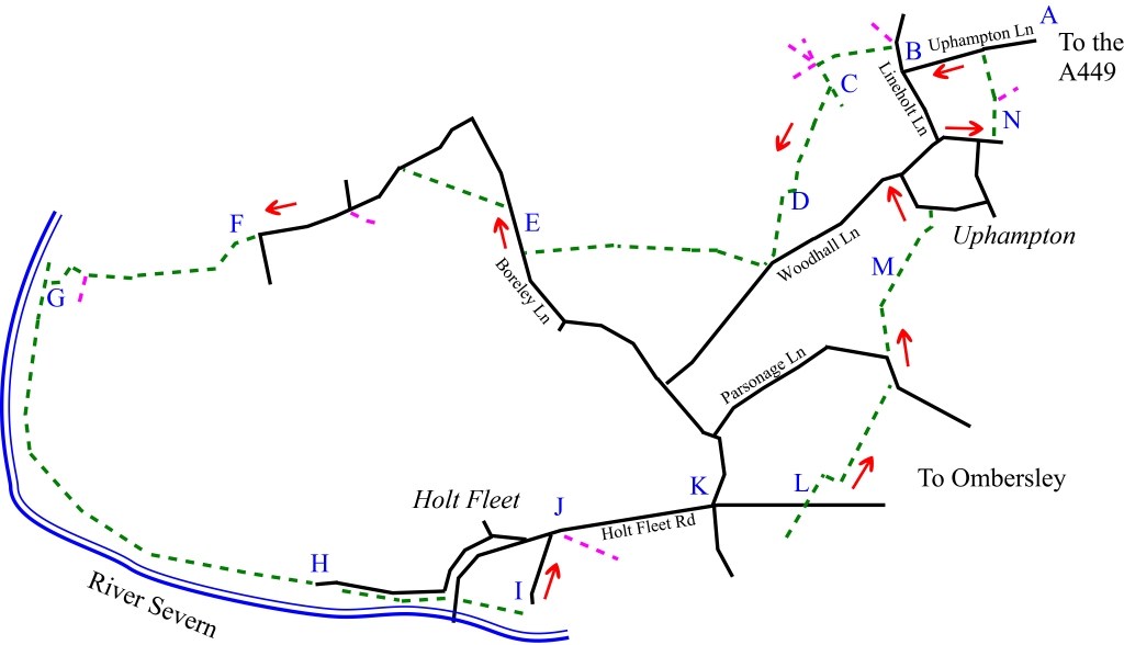
4.5 miles. Start/finish: The car park of the Fruiterer’s Arms, Uphampton, WR9 0JW near Ombersley. Terrain is good, through fields. Some stretches on roads. Most of the footpaths followed are clearly marked or signposted.

From the car park of the Fruiterer’s Arms (A) turn right and walk along the road, past the caravan park to the T-junction. Turn right and after a short distance take the footpath on your left (B) that follows the driveway ignoring the footpath on the right. Walk up the tarmac drive towards the two large houses. The footpath heads to the left and runs by the side of a wood. However you may find it easier to carry on up the drive (there are a number of footpaths that intersect here) and when the drive splits, head left, keeping the wood on your left (C).
You will then meet the signed footpath into the woods but you will turn right and cross the open grassed area to the next stile. The path is well-signed and crosses fields until it meets a track (D). Turn right, follow the track a few yards and then follow the path to your left. Again the path follows a straight line across a field and eventually meets a track with a road on your left which you will ignore. Instead, turn right and follow the path along the right-hand side of the hedgerow, crossing from the right to the left of the hedgerow halfway down the slope until it comes out on the road. Turn right and walk past Boreley House (E). Look out for the path on your left. Take the path across the field – you can see the signpost at the end of the field where it meets the road. Turn left and follow the road until it bends sharply to the left. At this point take the footpath/road (F) as it descends towards the caravan park and the River Severn (G). The path is clearly marked and follows an arc past holiday cottages and Holt lock (H). Follow the path under the bridge and onto the Wharf.
Between the pub buildings (I), the path turns left and runs past a caravan /camping site. Carefully cross the A4133, turn right (J) and follow Holt Fleet Road up the hill. At the junction (K) carry straight on. Ignore the first footpath on your left, but do take the second footpath into the field a little further on (L). At the end of the hedgerow, turn right towards the large tree and then left. Continue to Parsonage Lane where you will turn left. As the road turns to the left carry straight on into the next field. This path is not clear but runs uphill across a field (M) and heads to the house immediately to the right of the tennis court. The path goes over a stile and runs to the right of the house before coming out onto a road. You can take the circular road right or left. If going left ignore the two roads on your left or if going right, ignore the road on the right. Either way, you will meet a road junction and descend the hill. Take the path on your left (N). Follow this path in a straight line as it runs parallel to a hedge, and comes out close to the caravan park and the Fruiterer’s Arms.