7.5 miles. Start/finish: Rowberry’s Garden Centre, Chaddesley Corbett DY10 4QN. This walk is an interesting mix of paths, small settlements, minor roads, streams, a garden and woodland. Most of the paths are well-marked. There are a number of footpaths around Elmbridge Fishery which need more careful navigation.
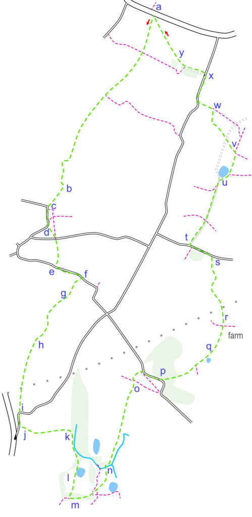
From the car park of the garden centre (a), take the style are carefully cross the A448 and cross the style. The Monarch’s Way path heads in an almost straight line (it’s easy to follow) through a point to point course, it is crossed by another footpath into another field (keep on the same line) and crosses into another field (ignore the path on your left), before it runs to the left of a hedge/fence. Then it cross another open field before running beside trees and then (b) turning left (up a slope) and right towards the settlement of Rushock.
Turn left when you meet the road (c) beside St Michaels Church (John Bonham’s Memorial Stone is here) and walk past the Village Hall. When the road bends to the right, take the path diagonally across the field (d). Cross the first road and continue along the same line until you meet Lunnon Ln (e) where you will turn left. Walk along this small lane until you meet and follow the path on your right (f) which follows a track to a cottage.
The path runs to the right of the cottage through a grassy area (g) towards and to the left (in the garden) of a large house (The Upper Hyde). Just keep going in a straight line. The path (marked) now veers slightly right through a gate onto a farm yard (Old Hyde Farm) before exiting the farm buildings (h) and heading up a slope towards a hedge. Follow the path beside the hedge (to your left) into the next field and under the pylons until you meet the small road (i) where you will turn right. Follow the road a short distance before crossing it just after the house and take the path (j) to the left.
The path runs in a straight line before entering a pretty wooded area and grassed path where (k) you will turn right. Follow the path through the woods, across a stream (head slightly right), up a slope and through a gate onto a service road (l). Turn right and follow the service road/track past the fish pond and farm (both on your left). Continue in a straight line up the slope towards the wooded area. As the track enters the wooded area it veers right (m). Look out and take the path which runs to the left. It follows the line of the wood a short distance before it meets another path that leads down across a field and toward the buildings. You will know you are on the well-marked path as you will pass through a gate, through a garden and over a low wall. Continue to follow the path through the pleasant garden, heading down the slope towards the trees (n).
Follow the path across the stream, through the trees to the right and left and across the horse jumps into the open area. The path now follows a fairly straight line, slightly uphill gradually veering to the left and through gates and stiles heading towards the farm/stables (o). Here it meets a track (ignore the path that crosses) which continues to the lane, where you turn right. A short distance along the lane you will pick up the path to the left (p).
The path leads to a footbridge over a stream (this area can be boggy) and onto open fields. The path curves and climbs to the left of the hedge/fence. Ignore the path that joins from the right and continue past the pond until you reach the gate and stile. From this point (q) you can see the route of the path. Head slightly to the left and downhill, away from the hedge you have just followed. Aim for the corner of the hedge on the opposite side of the field. Another path crosses here that to the right leads to the farm up the hill but you will keep straight on. With the hedge to your left (r) look out for the stile that takes you across the hedge and into the next field. The path now runs to the left of the hedge arcing gently to the left. You will pass under the high voltage cables and a pylon to right in the next field is a land mark. The path descends into a grassed field but continues to follow the line of the hedge until it meets the road (s).
Turn left at the road and walk a short distance before turning right onto the small road that is signposted to Purshall Green (t). Continue to the follow the small road but take the right hand fork at the pond (u) and follow this (ignore the path on the right) as it passes in front of the house. The path runs through a grassed area to the left of a hedge and meets another path to the right and left. Head left aiming to the left of the house (v) ahead of you and cross the track. Cross the stile and pick up the path as it diagonally crosses a grassed area, follows a hedge (on your left) and crosses a stile into a field. Cross this field, diagonally to the right and head for the gate (w). Go through the gate and turn left, keeping the hedge on your left. The path runs to the right of a house and exits onto a road where you will turn right.
Follow the road a short distance but left onto the track (x) and footpath. The path runs to the right of the track and through a few trees before coming out onto an open field, Ahead you can plot your path down the hill (y) and diagonally across the point-to-point course back to the gate where you cross the A448 again.