4 miles. There is a lay-by on Stourbridge Road, Bournheath B61 9LJ as you approach Fairfield and cross the M5 motorway. Terrain is generally good, through fields. Some small sections may be overgrown. Short distances on minor roads and footpaths; one along an A road verge. Most footpaths are well-marked.
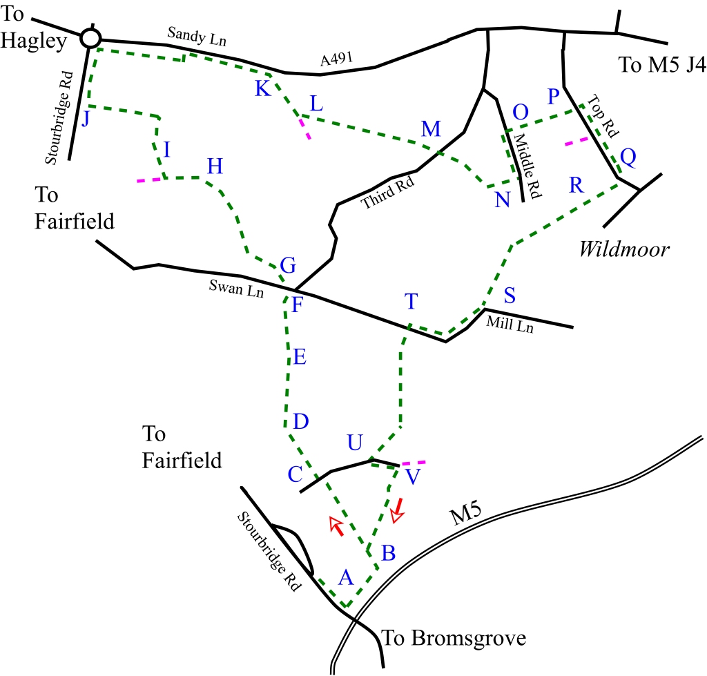
From the layby, follow the road down the hill towards the motorway, past Mayfield Farm. The path is signposted (A) and takes you round the side of the farm and over a stile. The path runs downhill with the motorway on your right. A short distance down the field (B) the path turns left through the middle of the field and continues in a straight line over a stile across a field until you reach a track (C). Continue straight across into another field and cross the stile in the corner (D).
The path crosses the field diagonally but before you get to the corner of the field (where there is a track if you miss it) climb the stile (E) on your right. The path passes close to the left-hand side of the tank (F) and emerges on the road. Cross the road and follow the next path which lies slightly to the left (G). The path follows the hedgerow and eventually crosses over it. After a short distance and two gates, a stile is crossed (H). The next stile is diagonally opposite but the official path follows the field boundary to the left up to a thicket, then right to a gate and then right again. Turn and cross the small field, go over the stile (I) and follow the path to the left up a steep hill. Go over the stile and continue straight down to the corner of the field and then follow the path to the right (J).
Follow the path, parallel to the road and over the stile as it curves to the right. The path will come out onto Sandy Lane (A491). Follow Sandy Lane to the right, past the quarry until you meet the path that leads diagonally right (K). Take this path with the hedge on your right until it splits in two. Take the left path and cross the field (L). The path crosses diagonally past the corner of a field to your right. On the opposite side of the field just to the left there is a stile (M) and this leads through an overgrown patch of land to the rear of the Cottage. The path takes you through a garden gate to the left of the cottage and by the side of the garage. Cross the road over the first and second stile on your left. The path crosses a field alongside a stream and comes out onto Middle Road between two houses (N). Turn left and follow the road until you meet the path on the right (O). Follow the path which follows the hedgerow (which is on your left) and turns left where it runs by the side of the Methodist church, eventually coming out into Top Road (P). Turn right and head for the Wildmoor Oak (Q). With the pub behind you pick up the path which is through the car park on your right. The path runs parallel to the stream, past a pond (R) and straight over a track, eventually coming out on a quiet lane (S). Follow the lane to the right, past the large buildings until you meet the path on the left (T).
Go over the fence and cross the field. Cross the next field diagonally until you meet the stile in the corner of the field. The path now runs close to a farm and meets a track (U). Turn left along the track towards Meadow Farm and then turn right taking the path into the next field (V). Ignore the kissing gate and path to the left and keep to the right of the mobile phone mast. The path crosses two hedgerows and leads into a ploughed field. Follow the path diagonally uphill until you meet the path you crossed at the start of the walk. Turn left and retrace your steps back to Stourbridge Road.